Marble Arch, Hyde Park, Mayfair and Shepherd Market - 3.0 km Route
- Philip Carey
- Oct 5
- 4 min read

Updated: Oct 14
This comprehensive set of guides for runners and walkers provides all the necessary information to complete the self-guided route in one place, allowing you to explore at your own pace. The route from Marble Arch into Hyde Park, into Mayfair via Park Lane and then to Hyde Park Corner through Speherd Market offers history, iconic sights, parks and gardens, squares, luxury shops, casinos, 5-star hotels, private clubs, parks and gardens, war memorials, bars, clubs and restaurants
The Familiarisation Guide provides all the core route information.
The Sightseeing Guide and Virtual tour guide add points of interest and 360-degree information.
The Connoisseur's Guide offers recommendations for places to eat, drink, and be entertained, as well as suggestions for exploring the surrounding areas and 'add-on' routes.

THE EXPERIENCE
This route travels across Mayfair from Marble Arch to Hyde Park Corner. Mayfair is famous for its affluent residents, luxury and high-end shopping streets, and Georgian and Victorian architecture. On its western edge is Hyde Park, on its eastern side are the luxury shops of Bond Street and Regent Street, and to its south are Hyde Park Corner, Green Park, and Buckingham Palace.
THE ROUTE FAMILIARISATION GUIDE (Level 1)
This guide provides you with the essential information you need to become familiar with the route before you arrive.
An overview map, My Google Map, and Strava Map to help guide you along the route
A video showing you what the route looks like as if you were running it at over 40 km/h.
Information to bear in mind along the route.
MAP OF THE ROUTE

The links to My Google and Strava Maps are designed to help you keep on track and limit the chances of getting lost. They don't provide turn-by-turn directions, but they do show your location relative to the route. They will open in a new tab.
The Google map shows the main route in red
HIGH SPEED VIDEO OF THE ROUTE
The high-speed video of the main red route is designed to get you visually familiar with the route ahead of your visit. It shows you a runner's view as if they were sprinting at over 40 km/h
THINGS TO BEAR IN MIND
The route is generally not very busy; however, the best time to complete it is in the early morning, especially on weekends when there are fewer crowds, the light is at its best, and you have the rest of the day ahead of you.
Expensive - Mayfair is one of London’s premier districts for both upscale shopping and fine dining, blending heritage, luxury, and haute couture. It's great on the eyes, but could burn a hole in your pocket, which is why it's best to do this route before the shops open!
Route and Accessibility – Mix of pavements and paths. The route is generally quiet except for Oxford Street at the start and Shepherd Market towards the end.
Route Blogs –Have the Blog and the Google, and the Strava Maps to hand for reference
THE ROUTE SIGHTSEEING GUIDE - (Level 2)
Once you are familiar with the route, the next time you take it, why not take the opportunity to familiarise yourself with the sights you can see along the way, take photos, and learn a bit about the area's history? The sights include:
Marble Arch
Animals in War Memorial
Mayfair's Shops and Architecture
Park Lane 5-Star Hotel
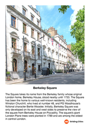
Berkeley Square
Shepherd Market
Green Park
Hyde Park Corner War Memorials
Belgravia.
For more information on these and other sights nearby, see the gallery and the supporting text below


Virtual Tour Guide
This virtual tour guide is designed to help you familiarise yourself with the route and enhance your memories of 'being there'. Clicking on the picture will take you to a new page showing a map of 360 locations in the area. Click on the location icons, and you will be transported to an interactive 360-degree view of that area - in a new tab.

THE ROUTE CONNOISSEUR'S GUIDE - (Level 3)
Once you are familiar with the route and its sights, why not become a connoisseur of the area and explore the surrounding routes that will uncover new things to see, places to eat, drink, and be entertained?
FOOD AND DRINK LOCATIONS
In Mayfair, the choices of where to eat and drink tend to be on the expensive side; however, most of these areas will have pubs where food and drink are much more reasonable. On or close to this route, these include the Audley Public House on Mount Street, the Footman on Chester Street, Ye Grapes and the King's Head in Shepherd Market, and the Guinea Grill on Bruton Place. Shepherd Market offers the widest range of venues, with most being reasonably priced, while Mount Street and the 5-star hotels by Hyde Park Corner feature a great selection of high-end options, such as Scott's and The Lanesborough Grill. Dover Street, North Audley Street, and Berkeley Street have a good range of venues to cater to most tastes.

THINGS TO DO LOCATIONS
This route presents a variety of activities designed to make you appreciate Mayfair as a destination for exploration. Mount Street and the surrounding shops near Berkeley Square offer luxurious shopping experiences, featuring everything from designer boutiques to high-end sports cars. Along this route, you'll encounter several of Mayfair's premier hotels, where you can enjoy an opulent afternoon tea or a cocktail in elegant settings. Alternatively, you can unwind in its numerous parks and gardens, admire the Georgian and Regency architecture, or visit the war memorials located on Park Lane and at Hyde Park Corner.

ROUTE EXTENTION
The map below and the My Google map link provide three extensions to the main route, helping you explore the area and find places to eat and drink. One at the start, one at the end and one in the middle. These are:
The North Mayfair Loop - 1.7 km
The Central Mayfair Loop - 1.5 km
The Belgrave Square Loop - 1.5 km

The Google map shows the main route in red and the additional extension routes in blue. A video and a more detailed explanation of these routes will be added shortly.
We will be launching new routes at regular intervals, so join our email list to get an early look at these and our other special blogs on London’s history and culture.


Comments