
Marylebone High Street and Oxford Street Shopping - Running and Walking Route (3.1 km)
- Philip Carey
- Oct 14, 2025
- 4 min read

Updated: Apr 21
Running and Walking Route Overview
Route: 15 of 16 — Across London Visual Marathon
Start: Baker Street Station
Finish: Marble Arch Station
Distance: 3.1 km
Estimated Time: 15-30 minutes
Difficulty: Easy to Moderate
Best Time: Early morning weekends
Overview: From Baker Street Underground Station, this route reveals three very different sides of London: the village calm of Marylebone High Street, the cultural depth of Wigmore Street and the Wallace Collection, and the famous bustle on Oxford Street by Selfridges — finishing at Marble Arch Underground Station.

The Experience
Starting at Baker Street Underground Station, this 3.1 km self-guided running and walking route explores the contrasting characters of the West End. Head south from the top of Marylebone High Street — regularly voted one of London's favourite village streets, lined with independent boutiques, artisan stores and restaurants — past the secluded Wallace Collection, home to one of the finest art collections in Europe, and then east along Wigmore Street, past Wigmore Hall (one of the world's great chamber music venues). The route finishes on the western section of Oxford Street by Selfridges, one of the world's most visited shopping streets, arriving at Marble Arch Underground Station. A route of quiet discovery, dramatic contrast, and world-class shopping.
The Familiarisation Guide
Essential information to help you become familiar with the route before you arrive.
Maps
Use the Google and Strava maps below to stay on track. They show your location relative to the route, helping you explore confidently without getting lost.
Please note: These don't provide turn-by-turn directions—we want you present and alert, using your senses, not glued to your screen.

Both maps will open in a new tab.
Watch the Route at Running Speed (Treadmill Version) 13:51
See the route from a runner's perspective as if you were running at 12 km/h. Watch this before you go to familiarise yourself visually with what's ahead.
What to Know Before You Go
Best Time to Stride:
The route is generally busy; however, early morning—especially on weekends—offers the best experience, with fewer crowds, the light at its best, and the rest of the day ahead of you.
Why Mornings are best:
In the early morning, Marylebone High Street retains its village charm without the crowds, and Oxford Street is transformed—empty pavements where you can appreciate the grand Victorian architecture without the retail chaos.
West End Shop Opening Hours:
Most shops generally open 09:00–20:00 or 21:00 on weekdays, with later hours on Thursdays and Saturdays, and shorter hours (approximately 12:00–18:00) on Sundays.
Accessibility:
A mix of pavements and paths. Generally busy after shops open. Oxford Street and its shops are often very crowded throughout the day.
Top Tip:
Have this guide and your chosen map (Google or Strava) available on your mobile for quick reference.
The Route Connoisseur Guide
Don't just run the route - get to know it!
Eating and drinking areas
Things to Do and Visit,
Sightseeing Gallery
Where to Eat & Drink - Key Dining Areas:
Marylebone Lane – Wide selection
North Audley Street – Good variety
Kingly Street – Vibrant dining scene
St Christopher's Place – Pedestrian area with cafés

Also Worth Exploring:
Marylebone High Street and Baker Street – A rich source of options
Moxon Street – Quality choices
South Moulton and adjoining streets – Good selection
North of Marble Arch – Edgware Road and Seymour Place
Things to Do
Shopping Experiences:
Marylebone High Street – Indulgent boutique shopping, village atmosphere
Oxford Street – Department stores (Selfridges, John Lewis, Marks & Spencer, Primark)
Wimpole Street – Specialist shops
Art & Culture:
Wigmore Hall – Classical music venue
The Wallace Collection – World-class art in Manchester Square (free entry)
Twist Museum – Immersive art on Oxford Street

Entertainment:
Madame Tussauds – Wax museum at the start
Planetarium – Near Baker Street
Peaceful Spaces:
Brown Hart Gardens – Hidden rooftop garden
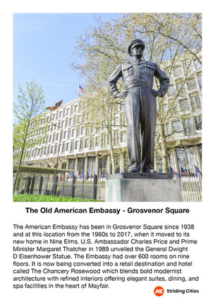
Grosvenor Square – Elegant square with American connections
Hyde Park – Escape to green space at the end of the route
The Sightseeing Guide
Once you know the route, dive deeper into the stories and sights that make this stride special.
Key Sights Along the Way
Madame Tussauds London
Marylebone High Street and Marylebone Lane
The Wallace Collection
Wigmore Hall
Cavendish Square
Harley Street and Wimpole Street
Hanover Square
St Christopher Place
New Bond Street
Selfridges
John Lewis
Primark and Marks & Spencer
Oxford Street
Marble Arch
Hyde Park and Speaker's Corner
Explore the gallery below for photos, history, and the stories behind each location.


360° Virtual Tour
Step into the route before you stride it—or relive your experience afterwards. Click the map below to explore interactive 360° views at key locations along the way.

The virtual tour opens in a new tab with a map showing all 360° locations. Click any location icon to be transported to that spot.
Follow-On Routes
Stride It Backwards:
Complete the route in reverse to experience London's ancient heart from a different perspective.
Previous Route: The BBC, Portland Place, Regent's Park & Baker Street – 3.1 km
Complete The Central London Collection Challenge - 9.2 km:
This route is number 15 and the second one in the London West End collection
