Discover Central London - Southbank & Westminster - 5.7 km
- Philip Carey
- Sep 18
- 5 min read

Updated: 4 days ago
This comprehensive set of guides for runners and walkers provides all the necessary information to complete this self-guided route in one place, allowing you to explore the route at your own pace. The areas covered include Covent Garden, the South Bank, the London Eye, views from Waterloo and Westminster Bridge, the Houses of Parliament, Westminster Abbey, Whitehall, St James's Park, Trafalgar Square and Leicester Square.
The Familiarisation Guide provides all the core route information.
The Sightseeing Guide and Virtual tour guide add points of interest and 360-degree information.
The Connoisseur's Guide offers recommendations for places to eat, drink, and be entertained, as well as suggestions for exploring the surrounding areas and 'add-on' routes.

THE EXPERIENCE
This Discovery route takes you from Covent Garden to Piccadilly Circus via the South Bank, Westminster, Whitehall, and Leicester Square and contains some of London’s most famous landmarks. It is a fantastic route for exploring the entertainment areas of Covent Garden and Leicester Square, as well as some of the main sightseeing attractions, including the Royal Festival Hall, the London Eye, Big Ben, Westminster Abbey, and Trafalgar Square.
THE ROUTE FAMILIARISATION GUIDE (Level 1)
This guide provides you with the essential information you need to become familiar with the route before you arrive.
An overview map, My Google Map, and Strava Map to help guide you along the route
A video showing you what the route looks like as if you were running it at over 40 km/h.
Information to bear in mind along the route.
MAP OF THE ROUTE

The links to My Google and Strava Maps are designed to help you keep on track and limit the chances of getting lost. They don't provide turn-by-turn directions, but they do show your location relative to the route. They will open in a new tab.
The Google map shows the main route in red
HIGH SPEED VIDEO OF THE ROUTE
The high-speed video of the main red route is designed to get you visually familiar with the route ahead of your visit. It shows you a runner's view as if they were doing it at over 40 km/h
THINGS TO BEAR IN MIND
The best time to do this route is in the early morning, especially on weekends when there are no crowds, the light is at its best, and you have the rest of the day ahead of you.
Planned events tend to take place in and around the Westminster - these include annual events such as the State Opening of Parliament and the Trooping of the Colour, and other smaller events, protests and marches in specific areas such as Parliament Square, Whitehall, Horse Guards Parade and Trafalgar Square
Much of the route is on pavements and roads, both of which will be crowded for most of the day and especially around the Houses of Parliament, Westminster Bridge, Whitehall, Leicester Square, Piccadilly Circus and all along the Southbank and in Covent Garden
Accessibility – There are several areas with steps, events and crowds
Attractions like the London Eye, Covent Garden, the London Dungeon, and Leicester Square tend to be busy most of the day, and it's best to get to these early.
THE ROUTE SIGHTSEEING GUIDE - (Level 2)
Once you are familiar with the route, the next time you take it, why not take the opportunity to familiarise yourself with the sights you can see along the way, take photos, and learn a bit about the area's history? The sights include:
Covent Garden
Somerset House
The Aldwych
Waterloo Bridge
Southbank Centre
Golden Jubilee Bridge
The London Eye
County Hall and its Amusement venues
Westminster Bridge, Big Benand The Houses of Parliament
Westminster Abbey
Horse Guards Parade, St James’s Park
Whitehall
Trafalgar Square
Leicester Square
Piccadilly Circus
For more information on these and other sights nearby, see the gallery and the supporting text below


Virtual Tour Guide
This virtual tour guide is designed to help you familiarise yourself with the route and enhance your memories of 'being there'. Clicking on the picture will take you to a new page showing a map of 360 locations in the area. Click on the location icons, and you will be transported to an interactive 360-degree view of that area - in a new tab.

THE ROUTE CONNOISSEUR'S GUIDE - (Level 3)
Once you are familiar with the route and its sights, why not become a connoisseur of the area and explore the surrounding routes that will uncover new things to see, places to eat, drink, and be entertained?
FOOD AND DRINK LOCATIONS
This map shows you some of the places to eat and drink along the route.
The areas in and around Covent Garden at the beginning of the route, and Leicester Square at the end of the route, have the largest selection of places to eat and drink. The area around the Southbank Centre also has a diverse selection of places to eat and drink, with a lively food market located behind the Royal Festival Hall, open on Fridays, Saturdays, and Sundays. Other locations include the area behind County Hall and around Charing Cross Station.

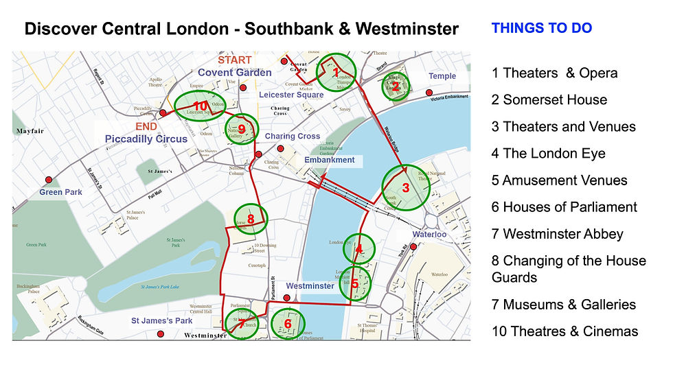
THINGS TO DO LOCATIONS
There are numerous activities to enjoy along this route, with each area offering something different. Covent Garden is home to the Royal Opera House, several theatres, the Transport Museum, and Somerset House. The area south of Waterloo Bridge is home to the National Theatre, the BFI, the Royal Festival Hall, the Hayward Gallery, the Purcell Rooms, and the Queen Elizabeth Hall. The attractions around County Hall include the London Eye, the London Dungeons, Sea Life London and Shrek Adventure. The locations near Parliament Square include tours of the Houses of Parliament and Westminster Abbey. At Horse Guards Parade, there is the daily Changing of the King's Life Guard and the Household Cavalry Museum. Towards the back of Trafalgar Square is the National Gallery and the Portrait Gallery, and between Leicester Square and Piccadilly Circus, there are many theatres, cinemas and casinos.
ROUTE EXTENTION
The map below and the My Google map link provide three extensions to the main route, helping you explore the area and find places to eat and drink. These are:
The St Giles Loop extension (1.0 km)
St James's Park and the Mall Extension (1.7 km)
Savile Row and Bond Street Extension (1.6 km)

The Google map shows the main route in red and the additional extension routes in blue. A video and a more detailed explanation of these routes will be added shortly.
FOLLOW ON ROUTES
If you want a 'follow-on' route, try the 'Royal London Sights - Pall Mall, Royal Parks & Palaces' 2.1 km route. This is part of a connected series of routes that will take you across London to Hyde Park.

We will be launching new routes at regular intervals, so join our email list or subscribe to this channel to get an early look at these and our other special blogs on London’s history and culture.


Comments