Trinity Wharf, East India Docks, City Island – Running and Walking Route (4.4 km)
Philip Carey
Oct 16, 2025
4 min read
Running and Walking Route Overview
Route: 2 of 16 — Across London Visual Marathon
Start: Royal Victoria DLR
Finish: East India DLR Station
Distance: 4.4 km
Estimated Time: 25-40 minutes (depending on pace)
Difficulty: Easy to Moderate
Overview: This East London route travels from Royal Victoria Docks to the East India DLR station, passing City Island, Trinity Buoy Wharf (home to London's only lighthouse), and the East India Basin nature reserve — a fascinating mix of cutting-edge regeneration and hidden history
The Experience
Starting at Royal Victoria DLR Station, this 4.4 km self-guided running and walking route reveals two very different sides of East London. Begin in the buzzing Royal Victoria Docks — home to watersports, the IFS Cloud Cable Car, and the dockside views — before crossing the Lower Lee to discover City Island, a striking new creative and residential quarter. Then, hidden just beyond, lies Trinity Buoy Wharf: London's only lighthouse, a thriving arts community, and views across the Thames that few visitors ever find. The route continues through the East India Basin nature reserve before finishing at East India DLR Station
The Familiarisation Guide
Essential information to help you become familiar with the route before you arrive.
Maps
Use the Google and Strava maps below to stay on track. They show your location relative to the route, helping you explore confidently without getting lost.
Please note: These don't provide turn-by-turn directions—we want you present and alert, using your senses, not glued to your screen.
Watch the Route at Running Speed (Treadmill Version) 22:06
See the route from a runner's perspective as if you were running at 12 km/h. Watch this before you go to familiarise yourself visually with what's ahead.
See the Trinity Wharf, East India Docks, City Island Route at Running Speed
What to Know Before You Go
Best Time to Stride:
The route is generally quiet with a few secluded spots—great to do at any time of the day.
Why Mornings are Best:
Early morning brings extra tranquillity to this already peaceful route. The creative spaces of Trinity Buoy Wharf feel even more magical in the soft morning light.
East India Basin:
Only opens from 08:00 until dusk.
Traffic Note:
Only an issue at the start, as the route runs close to the Silvertown Tunnel. Once past this point, it's peaceful throughout.
Accessibility:
Accessible throughout with a mix of pavements and riverside paths. The route can get slightly busier in the centre of City Island.
Top Tip:
Have this guide and your chosen map (Google or Strava) available on your mobile for quick reference.
The Route Connoisseur Guide
Don't just run the route - get to know it!
Eating and drinking areas
Things to Do and Visit,
Sightseeing Gallery
Where to Eat & Drink
Only a few dining locations along this route, but each has character:
Key Dining Areas:
Around the Waterfront – Near City Hall and nearby hotels at the start
City Island Centre – Several options in this new development
Trinity Buoy Wharf – Smaller selection with creative atmosphere
Things to Do
Main Attractions (Ticketed):
IFS Cloud Cable Car to the O2 – Aerial views across the Thames
English National Ballet – World-class performances on City Island
Free to Explore:
Trinity Buoy Wharf – Creative community, lighthouse, sculpture park
Bow Creek Ecology Park – Nature in the city
East India Basin Natural Reserve – Peaceful wildlife haven
Virginia Settlers Monument – Historic marker
Victoria Dock – Expansive waterfront views
City Hall – Modern architecture
The Sightseeing Guide
Once you know the route, dive deeper into the stories and sights that make this stride special.
Key Sights Along the Way
Victoria Dock
City Hall
IFS Cloud Cable Car
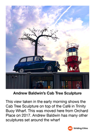
Trinity Buoy Wharf
Orchard Dry Dock
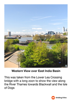
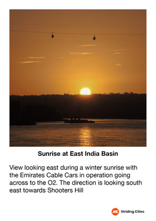
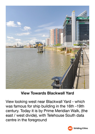
East India and River Views
Virginia Settlers Monument
City Island Gardens Activities
English National Ballet
Explore the gallery below for photos, history, and the stories behind each location.
360° Virtual Tour
Step into the route before you stride it—or relive your experience afterwards. Click the map below to explore interactive 360° views at key locations along the way.
Click on the picture to go to the 360 virtual tour map
The virtual tour opens in a new tab with a map showing all 360° locations. Click any location icon to be transported to that spot.
Follow-On Routes
Stride It Backwards:
Complete the route in reverse for a completely different perspective—Starting at the Tower from the City and heading towards the quieter docklands.
Complete The East London Collection Challenge - 14.4km:
This route is number 5 and the last one of the East London collection
The Full Collection:
This route is part of the Across London Visual Marathon collection—16 interconnecting routes covering 50.4 km from the Thames Barrier to Hyde Park - See the home page.