
The BBC, Portland Place, Regent’s Park & Baker Street - Running and Walking Route (3.1 km)
- Philip Carey
- Oct 13, 2025
- 4 min read

Updated: Apr 21
Running and Walking Route Overview
Route: 14 of 16 — Across London Visual Marathon
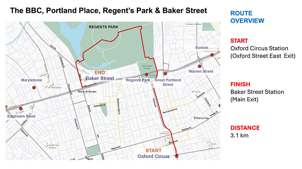
Start: Oxford Circus Station
Finish: Baker Street Station
Distance: 3.1 km
Estimated Time: 15-30 minutes
Difficulty: Easy to Moderate
Best Time: Early morning weekends
Terrain: Mix of pavements and park paths, watch for cyclists
Overview: From Oxford Circus, past the BBC up the grandeur of Portland Place and into the tranquil oasis of Regent's Park — finishing at Baker Street Station, close to the Sherlock Holmes Museum and Madame Tussauds.

The Experience
Starting at Oxford Circus Underground Station, this 3.1 km self-guided running and walking route takes you from the noise of London's busiest shopping street to one of its most serene green spaces. Pass BBC Broadcasting House and stride up the sweeping Geogian architecture of Portland Place — one of London's grandest avenues — before entering Regent's Park, where 166 hectares of royal parkland await. Wind through Queen Mary's Gardens, home to over 11,500 roses and one of the finest rose gardens in England, past the boating lake and Inner Circle, before finishing at Baker Street Underground Station — where Sherlock Holmes's fictional 221B is just steps away. This is London's great urban-to-green escape in 3.1 km.
The Familiarisation Guide
Essential information to help you become familiar with the route before you arrive.
Maps
Use the Google and Strava maps below to stay on track. They show your location relative to the route, helping you explore confidently without getting lost.
Please note: These don't provide turn-by-turn directions—we want you present and alert, using your senses, not glued to your screen.
Both maps will open in a new tab.
Watch the Route at Running Speed (Treadmill Version) 13:47
See the route from a runner's perspective as if you were running at 12 km/h. Watch this before you go to familiarise yourself visually with what's ahead..
What to Know Before You Go
Best Time to Stride:
The route is generally quiet; however, early morning—especially weekends—offers the best experience when it's peaceful, the light is at its finest, and you have the rest of the day ahead of you.
West End Shop Opening Hours:
Most shops generally open 09:00–20:00 or 21:00 on weekdays, with later hours on Thursdays and Saturdays, and shorter hours (approximately 12:00–18:00) on Sundays.
Park Opening Times:
Pedestrian gates open from 05:00, as do most toilets. Closing times vary seasonally—from 16:00 in winter to 21:30 in summer.
Accessibility:
Mix of pavements and paths. It can be crowded at the start and end. Many cyclists are racing around Regent's Park—be alert on the Outer Circle.
Top Tip:
Have this guide and your chosen map (Google or Strava) available on your mobile for quick reference.
The Route Connoisseur Guide
Don't just run the route - get to know it!
Eating and drinking areas
Things to Do and Visit,
Sightseeing Gallery
Where to Eat & Drink
The main dining areas are slightly away from the route, but worth exploring.
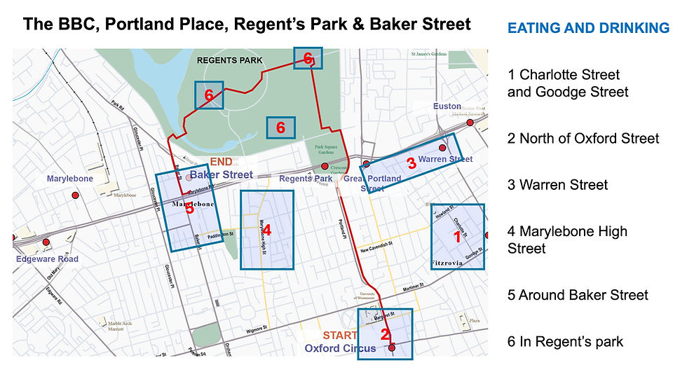
Eastern Side:
Charlotte Street – Excellent restaurant selection
Goodge Street – Good variety
Streets parallel to and north of Oxford Street – Wide selection
Southeast of Baker Street:
Marylebone High Street – Great shops and dining
Along the Route:
Warren Street – Smaller selection
Regent's Bar & Kitchen (western side by Inner Circle) – Tasty hot breakfasts, lunch, ice cream sundaes, sandwiches
Things to Do
Portland Place:
The BBC – Historic Broadcasting House
The Langham Hotel – Victorian grandeur
All Souls Church – Nash's architectural gem
Georgian Architecture – Regency elegance from the early 1800s

Regent's Park Highlights:
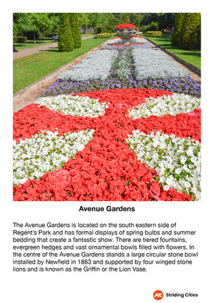
Avenue Gardens – Seasonal flower displays
Regent's Park Open Air Theatre – Summer performances
Queen Mary's Gardens – 40,000 roses
Boating Lake – Picturesque waters
Wildlife Spotting – Herons, waterfowl, and more
London Zoo – World-famous zoo (separate admission)
Sports Facilities – Various activities available
Baker Street Area:
Madame Tussauds London – Wax museum
The Sherlock Holmes Museum – 221b Baker Street
Marylebone High Street – Shopping and dining
The Sightseeing Guide
Once you know the route, dive deeper into the stories and sights that make this stride special.
Key Sights Along the Way
Oxford and Regent Street Shops
The BBC
The Langham Hotel
Great Portland Street
Regent's Park (Avenue Gardens, Queen Mary's Garden, Boating Lake)
The Sherlock Holmes Museum
Madame Tussauds London
Explore the gallery below for photos, history, and the stories behind each location.


360° Virtual Tour
Step into the route before you stride it—or relive your experience afterwards. Click the map below to explore interactive 360° views at key locations along the way.

The virtual tour opens in a new tab with a map showing all 360° locations. Click any location icon to be transported to that spot.
Follow-On Routes
Stride It Backwards:
Complete the route in reverse to experience London's ancient heart from a different perspective.
Previous Route: Bond Street, Regent Street & Carnaby Street Shopping – 1.4 km
Complete The Central London Collection Challenge - 9.2 km:
This route is number 14 and the third one in the London West End collection
