Royal Docks, ExCel Centre & City Hall – Running and Walking Route (1.7 km)
Philip Carey
Oct 16, 2025
4 min read
The Running and Walking Route Overview
Route: 1 of 16— Across London Visual Marathon
Start: Custom House DLR (near ExCel)
Finish: Royal Victoria DLR
Distance: 1.7 km
Estimated Time: 10-20 minutes
Difficulty: Easy
Best Time: Early morning
Overview: This compact East London route loops the historic Royal Victoria Dock, passing the ExCel Exhibition Centre, the Royal Victoria Footbridge, City Hall, and the IFS Cloud Cable Car, with an optional visit to the Thames Barrier.
The Experience
Starting at Custom House DLR Station, this 1.7 km self-guided running and walking route takes you around the iconic Royal Victoria Dock — one of the world's great Victorian engineering achievements, opened in 1855 for the largest steam ships of the Empire. Today, its waterways are peaceful and spectacular. Stride along the ExCel Centre waterfront, cross the Royal Victoria Footbridge with panoramic views of Docklands, Millennium Mill, and City Airport, then continue past water sports, City Hall, and the IFS Cloud Cable Car. Finish at Royal Victoria DLR Station — with an optional Thames Barrier extension on offer. This short visual route blends London's industrial heritage with its Olympic regeneration story, all set against the peaceful, reflective waters of the Royal Docks
THE ROUTE FAMILIARISATION GUIDE
Essential information to help you become familiar with the route before you arrive.
Maps
Use the Google and Strava maps below to stay on track. They show your location relative to the route, helping you explore confidently without getting lost.
MAP OF THE ROUTE
Please note: These don't provide turn-by-turn directions—we want you present and alert, using your senses, not glued to your screen.
Watch the Route at Running Speed (Treadmill Version) 9:54
See the route from a runner's perspective as if you were running at 12 km/h. Watch this before you go to familiarise yourself visually with what's ahead.
See the Royal Docks, ExCel Centre & City Hall Route at High Speed
What to Know Before You Go
Best Time to Stride:
Early mornings offer the best experience, though the route remains quiet most of the day except around Custom House station and the ExCel Centre during exhibitions.
Why Mornings are Best:
In the early morning light, the dock waters reflect the sky perfectly, and you'll have the waterfront paths largely to yourself. The sense of space and tranquillity here is remarkable.
ExCel Centre:
Numerous places to eat and drink, but generally only open to the public during events.
IFS Cloud Cable Car:
Generally open 09:00–21:00. Offers stunning aerial views of the O2 ad Canary Wharf
Thames Barrier Optional Extension:
Thames Barrier Park opening times: 07:00–16:30
Development works around Millennium Mill may continue until the year 2030 (this is a £3.5bn project)
Accessibility:
All off-road. Note: No step-free access to Royal Victoria Dock Footbridge.
Top Tip:
Have this guide and your chosen map (Google or Strava) available on your mobile for quick reference.
The Route Connoisseur Guide
Don't just run the route - get to know it!
Eating and drinking areas
Things to Do and Visit,
Sightseeing Gallery
Where to Eat & Drink
There aren't many places to eat and drink directly along this route, but several good options exist:
Key Dining Areas:
Around ExCel Centre – A few options outside, plenty more within when open to the public
South of North Woolwich Road – New development with dining options
Royal Victoria Dock Hotels – Several hotel bars and restaurants
IFS Cloud Cable Car Area – Limited options nearby by the water front
Dock Beach – Casual dining by the water
Notable Mention: Sunborn Yacht Hotel – A pleasant spot for afternoon tea overlooking the water, plus a good restaurant and bar.
Things to Do/Worth Exploring:
1 ExCel Exhibition Centre: A wide range of events from major conferences and trade shows to immersive experiences and sporting spectacles.
2 Sunborn Yacht Hotel – Impressive vessel, restaurant, and bar
3 Victoria Dock Footbridge – Fantastic views across the docks
4 Thames Gardens – Engineering marvel, well worth the visit
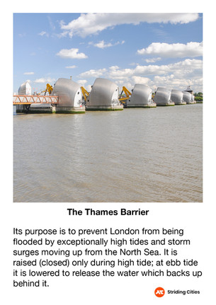
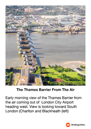
5 Thames Barrier – Engineering marvel well worth the visit
6 IFS Cloud Cable Car – Cross the Thames to the O2 for activities, views, and dining
7 City Hall and Dockside views – Beautiful waterfront perspectives
8 Dock Beach – Watersports and casual dining
The Sightseeing Guide
Once you know the route, dive deeper into the stories and sights that make this stride special.
Key Sights Along the Way
Millennium Mill
Britannia Village
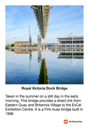
Victoria Dock Bridge
ExCel Centre
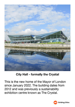
City Hall
Water Sport Centre
IFS Cloud Cable Car
Thames Barrier (Optional)
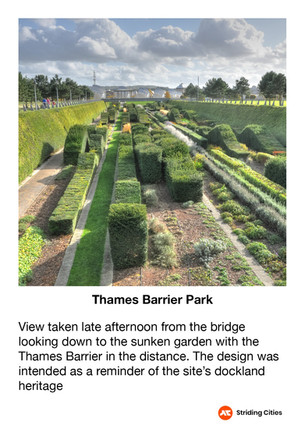
Thames Barrier Park (Optional)
Explore the gallery below for photos, history, and the stories behind each location.
Virtual Tour Guide
Step into the route before you stride it—or relive your experience afterwards. Click the map below to explore interactive 360° views at key locations along the way.
Click on the picture to go to the 360 virtual tour map
The virtual tour opens in a new tab with a map showing all 360° locations. Click any location icon to be transported to that spot.
The Connoisseur's Guide
Know the route well? Time to become a connoisseur. Discover the best places to eat, drink, and new areas to explore in the surrounding area.
Route Extensions
Stride It Backwards: Complete the route in reverse to test your navigational and visual skills whilst cementing what you've learnt.
Thames Barrier Loop – 2.6 km:
Explore more of the area with this extension. See the Google map link for the route (shown in blue). Detailed guide and video coming soon.
The Google map shows the main route in red and the additional extension routes in blue. A video and a more detailed explanation of these routes will be added shortly.
Follow-On Routes
Stride It Backwards:
Complete the route in reverse for a completely different perspective—Starting at the Tower from the City and heading towards the quieter docklands.
Complete The East London Collection Challenge - 14.4km:
This route is number 1 and the first one of the East London collection
The Full Collection:
This route is part of the Across London Visual Marathon collection—16 interconnecting routes covering 50.4 km from the Thames Barrier to Hyde Park - See the home page.