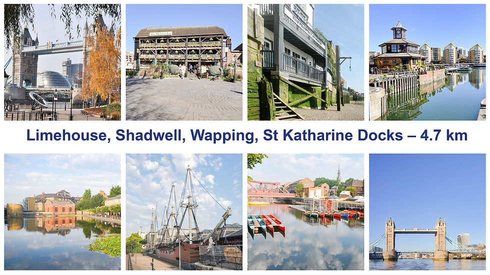
Limehouse, Shadwell, Wapping, St Katharine Docks – Running and Walking Route (4.7 km)
Philip Carey
Oct 17, 2025
4 min read
Running and Walking Route Overview
Route: 5 of 16 — Across London Visual Marathon
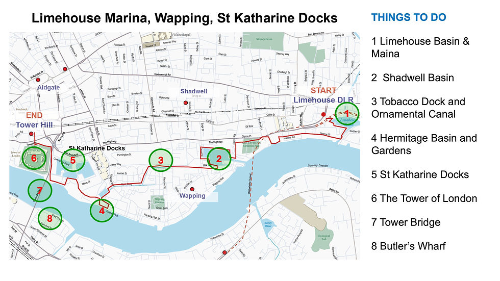
Start: Limehouse DLR
Finish: Tower Hill Station
Distance: 4.7 km
Estimated Time: 25-40 minutes
Difficulty: Easy to Moderate
Best Time: Early morning any day, quietest on weekends.
Overview:A riverside journey from Limehouse DLR through some of the Thames Path's most historically layered stretches — past Shadwell Basin, the former site of the London Docks and Tobacco Dock, and into St Katharine Docks beside the Tower of London
The Experience
Starting at Limehouse DLR Station, this 4.7 km self-guided running and walking route follows the Thames Path through some of East London's most historically layered neighbourhoods. From Limehouse Basin Marina, the route hugs the river through Shadwell Basin and the Wapping — once the heart of London's maritime trade, where sailors, pirates, and merchants lived side by side. Pass Tobacco Dock and what remains of London Dock before arriving at the stunning St Katharine Docks, London's most famous marina, and finishing at Tower Hill Underground Station in the shadow of the Tower of London. This is a route where every bend in the river reveals another chapter of the city's docklands' story.
The Familiarisation Guide
Essential information to help you become familiar with the route before you arrive.
Maps
Use the Google and Strava maps below to stay on track. They show your location relative to the route, helping you explore confidently without getting lost.
Please note: These don't provide turn-by-turn directions—we want you present and alert, using your senses, not glued to your screen.
Watch the Route at Running Speed (Treadmill Version) 25:02
See the route from a runner's perspective as if you were running at 12 km/h. Watch this before you go to familiarise yourself visually with what's ahead.
The route is quiet along most of the way, except around the Tower of London at the end. Great to do at any time, but early morning is best—the light is at its finest, and it's even quieter.
Why Mornings are Best:
In the early morning, the Thames reflects the sky beautifully, and historic Wapping feels like you've stepped back in time. The Tower of London, without the crowds, is an unforgettable sight.
Tideway Tunnel Works:
Near King Edward Memorial Park (Shadwell), works are still ongoing with a temporary Thames Path diversion in place until mid 2026.
Tower of London:
Open from 09:00 Tuesday–Saturday and 10:00 on Sundays. Tower Wharf by the river opens from 07:00.
Accessibility:
Mainly off-road with some uneven surfaces and a few steps.
Top Tip:
Have this guide and your chosen map (Google or Strava) available on your mobile for quick reference.
The Route Connoisseur Guide
Don't just run the route - get to know it!
Eating and drinking areas
Things to Do and Visit,
Sightseeing Gallery
Where to Eat & Drink
Not many places along this route, but the ones that exist are characterful and worth discovering.
Key Dining Spots:
Gordon Ramsay's Bread Street Kitchen – At the start, excellent dining
The Prospect of Whitby – Historic pub at Shadwell, London's oldest riverside tavern
Town of Ramsgate Pub – Historic watering hole
Smith's Restaurants – By Hermitage Riverside Memorial Gardens
St Katharine Docks – Several options around the marina at the end
Around Tower of London – Various choices near the finish
Things to Do
The route offers many attractions for the eyes and is easy on your pocket, giving you a grand entrance into the City of London.
Key Attractions:
Tower of London – A ticketed attraction (entrance fee applies if you want to go inside)
Tower Bridge – Iconic views (there is also the Tower Bridge Experience - a ticketed attraction)
Thames Path Views – Free and spectacular throughout
Historic Pubs – Prospect of Whitby, Captain Kidd, Town of Ramsgate
St Katharine Docks – Beautiful marina to explore
Hermitage Riverside Memorial Garden – Peaceful green space
Tower Bridge – Iconic views (free to walk across)
Shadwell Basin – Former dock now used for water activities
The Sightseeing Guide and Gallery
Once you know the route, dive deeper into the stories and sights that make this stride special.
Key Sights Along the Way
Limehouse Marina
Start of the Regent's Canal
Thames Path Riverside Views
King Edward Memorial Park
Shadwell Basin
The Prospect of Whitby
Tobacco Dock
The Ornamental Canal
Hermitage Basin and Gardens
St Katharine Docks
Tower of London
Tower Bridge
Explore the gallery below for photos, history, and the stories behind each location.
360° Virtual Tour
Step into the route before you stride it—or relive your experience afterwards. Click the map below to explore interactive 360° views at key locations along the way.
Click on the picture to go to the 360 virtual tour map
The virtual tour opens in a new tab with a map showing all 360° locations. Click any location icon to be transported to that spot.
Follow-On Routes
Stride It Backwards:
Complete the route in reverse for a completely different perspective—Starting at the Tower from the City and heading towards the quieter docklands.
Complete The East London Collection Challenge - 14.4km:
This route is number 5 and the last one of the East London collection
The Full Collection:
This route is part of the Across London Visual Marathon collection—16 interconnecting routes covering 50.4 km from the Thames Barrier to Hyde Park - See the home page.