
Docklands – Poplar Dock, Canary Wharf, South Dock – Running and Walking Route (4.0 km)
- Philip Carey
- Oct 16, 2025
- 4 min read

Updated: Jun 4
Running and Walking Route Overview
Route: 3 of 16 — Across London Visual Marathon
Start: East India DLR
Finish: Canary Wharf Underground Station
Distance: 4.0 km
Estimated Time: 20-35 minutes (depending on pace)
Difficulty: Moderate
Overview: From East India DLR station, this route loops through the tranquil Poplar Dock Marina and Blackwall Basin before reaching the spectacular east side of Canary Wharf, exploring Harbour Quay and the South Dock — the financial district at its most scenic

The Experience
Starting at East India DLR Station, this 4.0 km self-guided running and walking route offers one of the most dramatic approaches to Canary Wharf you'll find on foot. It will take you to the peaceful calm of Poplar Dock Marina and Blackwall Basin, where narrowboats and still water create a strong contrast with what's ahead. As the route turns west, Canary Wharf's glass towers rise dramatically above you, reflected in the still waters of Blackwall Basin. Explore the east side of Canary Wharf via Harbour Quay and the serene South Dock pathway before finishing at Canary Wharf Station.
The Familiarisation Guide
Essential information to help you become familiar with the route before you arrive.
Maps
Use the Google and Strava maps below to stay on track. They show your location relative to the route, helping you explore confidently without getting lost.
Please note: These don't provide turn-by-turn directions—we want you present and alert, using your senses, not glued to your screen.

Both maps will open in a new tab.
Watch the Route at Running Speed (Treadmill Version) 17:41
See the route from a runner's perspective as if you were running at 12 km/h. Watch this before you go to familiarise yourself visually with what's ahead.
What to Know Before You Go
Best Time to Stride:
The route is generally quiet until you reach Canary Wharf, with the busiest spots around stations and shopping centres. Early morning—especially weekends—offers the best light, fewest crowds, and the rest of the day ahead of you.
Why Mornings are Best:
In the early morning, the water reflections in Blackwall Basin are stunning, and you'll have Canary Wharf's plazas largely to yourself. The contrast between the peaceful marina and the awakening financial district is remarkable.
Food & Drink and Shops:
300+ shops, cafés, bars, and restaurants within Canary Wharf's five shopping malls, plus stunning riverside locations. Opening times
Monday–Friday: 9 am–8 pm
Saturday: 10 am–7 pm
Sunday: 12 pm–6 pm
Billingsgate Fish Market:
Open Tuesday–Saturday, 4 am–8:30 am. Visitors should be aware of health and safety restrictions (no children under 12 or dogs on the market floor). Be cautious of moving forklifts and porters.
Accessibility:
Mainly pavements, a few dockside paths, and several areas with steps within Canary Wharf.
Top Tip:
Have this guide and your chosen map (Google or Strava) available on your mobile for quick reference.
The Route Connoisseur Guide
Don't just run the route - get to know it!
Eating and drinking areas
Things to Do and Visit,
Sightseeing Gallery
Where to Eat & Drink
Canary Wharf is home to an abundance of cultures and cuisines to suit every palate—but you sometimes have to go looking for it.

Key Dining Areas:
Harbour Quay – Dockside dining with water views
Jubilee Place & Canary Wharf Shopping Centres – Food halls with variety
Crossrail Place – Near the station, convenient for pre or post-stride refreshments
South Dock – Waterside options with views
Find Your Perfect Spot: -
Browse the full directory at canarywharf.com/eating-drinking
Things to Do
Canary Wharf provides plenty of options to suit most tastes and ages, though they're not always easy to find.
The map below highlights:
Best viewpoints
Free cultural spaces
Visual attractions worth discovering

Worth Exploring:
Best viewpoints of Canary Wharf's iconic skyline
Public art installations throughout the estate
Crossrail Place Roof Garden – A hidden oasis
Dockside walks with spectacular reflections
Free cultural spaces and visual attractions
Full Guide:
Visit canarywharf.com/see-do for the complete list of activities and events.
The Sightseeing Guide
Once you know the route, dive deeper into the stories and sights that make this stride special.
Key Sights Along the Way
Poplar Docks
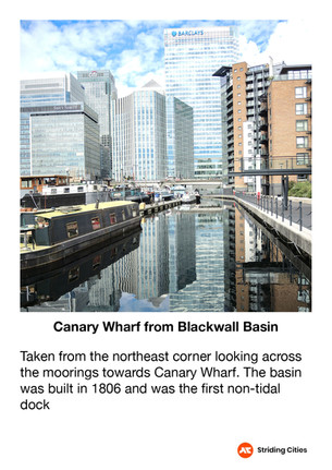
Blackwall Basin
Billingsgate Market
Coldharbour
Blue Bridge Lock Views
Harbour Quay
Crossrail Place
Jubilee Park
South Dock Views
Millwall Dock
South Quay Footbridge
Underground Shopping Centre
Explore the gallery below for photos, history, and the stories behind each location.


360° Virtual Tour
Step into the route before you stride it—or relive your experience afterwards. Click the map below to explore interactive 360° views at key locations along the way..

The virtual tour opens in a new tab with a map showing all 360° locations. Click any location icon to be transported to that spot
Follow-On Routes
Stride It Backwards:
Complete the route in reverse for a completely different perspective —Starting at the Tower from the City and heading towards the quieter docklands.
Previous Route: [Trinity Wharf, East India Docks, City Island – 4.4 km]
Next Route: Docklands: [Middle Dock, Westferry & Limehouse – 2.3 km]
Complete The East London Collection Challenge - 14.4km:
This route is number 3 and the third one in the East London collection
