Docklands – Middle Dock, Westferry & Limehouse – Running and Walking Route (2.3 km)
Philip Carey
Oct 16, 2025
4 min read
Running and Walking Route Overview
Route: 4 of 16 — Across London Visual Marathon
Start: Canary Wharf Station
Finish: Limehouse DLR Station
Distance: 2.3 km
Estimated Time: 15-25 minutes
Difficulty: Easy
Best Time: Early morning, weekends
Overview: A compact but visually stunning Docklands route from Canary Wharf through Middle Dock to the peaceful waters of Limehouse Marina, where glass towers give way to cobbled streets and converted warehouses.
The Experience
Starting at Canary Wharf Station, this 2.3 km self-guided running and walking route is a journey through contrasts — from gleaming glass towers to cobbled maritime streets. Stride through Jubilee Place Park before emerging into Canary Wharf Plaza with its dramatic Middle Dock views, then follow the Thames Path from Westferry Circus, cross Limekiln Dock Bridge onto the historic Narrow Street, and wind through Ropemakers Park to arrive at the tranquil Limehouse Marina — finishing at Limehouse DLR Station. London's river has always been its lifeblood, and this route reveals that story in under 2.5 kilometres
The Familiarisation Guide
Essential information to help you become familiar with the route before you arrive.
Maps
Use the Google and Strava maps below to stay on track. They show your location relative to the route, helping you explore confidently without getting lost.
Please note: These don't provide turn-by-turn directions—we want you present and alert, using your senses, not glued to your screen.
Watch the Route at Running Speed (Treadmill Version) 13:25
See the route from a runner's perspective as if you were running at 12 km/h. Watch this before you go to familiarise yourself visually with what's ahead.
Weekends in the early morning offer the best lighting and thefewest crowds. Canary Wharf is busy during weekdays but quiet along the rest of the route, especially in Ropemakers Park and Limehouse Marina.
Why Mornings are Best:
This route truly shines in the early morning when the light catches the glass towers, and the dockside reflections are at their most beautiful. You'll have the paths largely to yourself, with just the city waking up around you.
Food & Drink and Shops:
300+ shops, cafés, bars, and restaurants within Canary Wharf's five shopping malls, plus stunning riverside locations.
Monday–Friday: 9 am–8 pm
Saturday: 10 am–7 pm
Sunday: 12 pm–6 pm
Accessibility:
A mix of pavements, parks, dockside and riverside paths with steps around Cabot Square and Westferry. Generally accessible, but some elevation changes.
Top Tip:
Have this guide and your chosen map (Google or Strava) available on your mobile for quick reference.
The Route Connoisseur Guide
Don't just run the route - get to know it!
Eating and drinking areas
Things to Do and Visit,
Sightseeing Gallery
Where to Eat & Drink
Canary Wharf offers 300+ dining options—you just need to know where to look.
Key Dining Areas:
Harbour Quay – Dockside dining with water views
Jubilee Place & Canary Wharf Shopping Centres – Food halls with variety
Crossrail Place – Near the station, convenient for pre- or post-stride refreshments
North Dock – By the Docklands Museum and Cabot Square
Once you know the route, dive deeper into the stories and sights that make this stride special.
Key Sights Along the Way
South Dock Views
South Quay Footbridge
Jubilee Park
Middle Dock Views
Canary Wharf Plaza and Views
Cabot Square and Shopping Centre
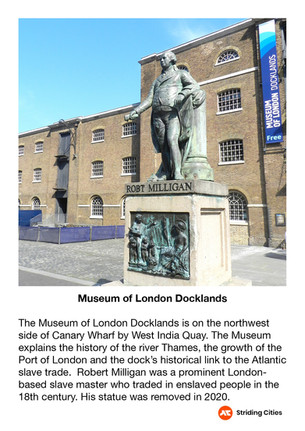
Museum of London Docklands and North Dock
Westferry Circus
Thames Path Riverside Views
Ropemaker Park
Limehouse Marina
Explore the gallery below for photos, history, and the stories behind each location.
360° Virtual Tour
Step into the route before you stride it—or relive your experience afterwards. Click the map below to explore interactive 360° views at key locations along the way.
Click on the picture to go to the 360 virtual tour map
The virtual tour opens in a new tab with a map showing all 360° locations. Click any location icon to be transported to that spot.
Follow-On Routes
Stride It Backwards:
Complete the route in reverse for a completely different perspective—Starting at the Tower from the City and heading towards the quieter docklands.
Complete The East London Collection Challenge - 14.4km:
This route is number 4 and the fourth one in the East London collection
The Full Collection:
This route is part of the Across London Visual Marathon collection—16 interconnecting routes covering 50.4 km from the Thames Barrier to Hyde Park - See the home page.