
Covent Garden, London Eye, Big Ben, Leicester Square - Running & Walking Route (5.7 km)
- Philip Carey
- Oct 13, 2025
- 4 min read

Updated: Apr 21
Running and Walking Route Overview
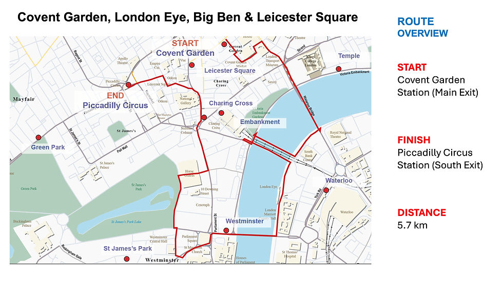
Route: 11 of 16 — Across London Visual Marathon.
Start: Covent Garden Station
Finish: Piccadilly Circus Station
Distance: 5.7 km
Estimated Time: 30-50 minutes
Difficulty: Moderate
Best Time: Early morning weekends
Overview: The longest single route in the series and one of London's great sightseeing runs — from Covent Garden, the South Bank, the London Eye, Big Ben, Westminster Abbey, Whitehall, Leicester Square and Trafalgar Square, finishing at Piccadilly Circus Station.

The Experience
Starting at Covent Garden Station, this 5.7 km self-guided running and walking route is the ultimate London sightseeing experience on foot — passing more of the capital's world-famous landmarks in a single route than almost any other. From Covent Garden and across Waterloo Bridge, the route sweeps down to the South Bank with views of the London Eye, then across to Big Ben, the Houses of Parliament, and Westminster Abbey — before veering off to Piccadilly Circus via St James's Park, Whitehall, Trafalgar Square and Leicester Square. Early morning is the best time, as it's quiet and you can get to all these iconic spots without crowds.
The Familiarisation Guide
Essential information to help you become familiar with the route before you arrive.
Maps
Use the Google and Strava maps below to stay on track. They show your location relative to the route, helping you explore confidently without getting lost.
Please note: These don't provide turn-by-turn directions—we want you present and alert, using your senses, not glued to your screen.
Both maps will open in a new tab.
Watch the Route at Running Speed (Treadmill Version) 24:43
See the route from a runner's perspective as if you were running at 12 km/h. Watch this before you go to familiarise yourself visually with what's ahead.
What to Know Before You Go
Best Time to Stride:
Early morning, especially weekends, when there are no crowds, the light is at its best, and you have the rest of the day ahead of you.
Why Mornings are best:
In the early morning, Westminster is transformed. Big Ben chimes across an empty Parliament Square, the Thames reflects golden light, and you can photograph iconic landmarks without a soul in sight. This is when the capital feels most majestic.
Planned Events:
Events often take place around Westminster—annual occasions like the State Opening of Parliament and Trooping the Colour, plus protests and marches in Parliament Square, Whitehall, Horse Guards Parade, and Trafalgar Square.
Crowds:
Much of the route is on pavements and roads that are crowded most of the day, especially around:
Houses of Parliament and Westminster Bridge
Whitehall
Leicester Square and Piccadilly Circus
Southbank
Covent Garden
Accessibility:
Several areas with steps, events, and crowds throughout.
Popular Attractions:
London Eye, Covent Garden, London Dungeon, and Leicester Square tend to be busy most of the day—best to visit early.
Top Tip:
Have this guide and your chosen map (Google or Strava) available on your mobile for quick reference.
The Route Connoisseur Guide
Don't just run the route - get to know it!
Eating and drinking areas
Things to Do and Visit,
Sightseeing Gallery
Where to Eat & Drink - Key Dining Areas:
Covent Garden – Largest selection at the beginning of the route
Southbank Centre Area – Diverse selection, lively food market behind Royal Festival Hall (open Fri–Sun)
Behind County Hall – Several options
Around Charing Cross Station – Good variety
Leicester Square – Extensive variety towards the end of the route

Things to Do
Each area offers something different along this landmark-rich route.
Covent Garden Area:
Royal Opera House
Several theatres
Transport Museum
Somerset House (events, river views, galleries)
South of Waterloo Bridge:
National Theatre
BFI (British Film Institute)
Royal Festival Hall
Hayward Gallery
Purcell Rooms
Queen Elizabeth Hall
County Hall Area:
London Eye
London Dungeons
Sea Life London
Shrek's Adventure

Westminster:
Houses of Parliament tours
Westminster Abbey
Churchill War Rooms
Horse Guards Parade:
Daily Changing of the King's Life Guard
Household Cavalry Museum
Trafalgar Square Area:
National Gallery
National Portrait Gallery
Leicester Square to Piccadilly Circus:
Numerous theatres
Cinemas
Entertainment venues
The Sightseeing Guide
Once you know the route, dive deeper into the stories and sights that make this stride special.
Key Sights Along the Way
Covent Garden
Somerset House
The Aldwych
Waterloo Bridge
Southbank Centre
Golden Jubilee Bridge
The London Eye
County Hall and Amusement Venues
Westminster Bridge, Big Ben and Houses of Parliament
Westminster Abbey
Horse Guards Parade, St James's Park
Whitehall
Trafalgar Square
Leicester Square
Piccadilly Circus
Explore the gallery below for photos, history, and the stories behind each location.


360° Virtual Tour
Step into the route before you stride it—or relive your experience afterwards. Click the map below to explore interactive 360° views at key locations along the way.

The virtual tour opens in a new tab, displaying a map of all 360° locations. Click any location icon to be transported to that spot.
Follow-On Routes
Stride It Backwards:
Complete the route in reverse to experience London's ancient heart from a different perspective.
Previous Route: Old Bailey, Smithfield, Holborn & Inns of Court – 4.0 km
This route is number 11 and the first one in the Central London collection
