
City of London, Skyscrapers, Bank of England and The Shard - Running and Walking Route (4 km)
- Philip Carey
- Oct 13, 2025
- 4 min read

Updated: Apr 21
Running and Walking Route Overview
Route: 8 of 16 — Across London Visual Marathon
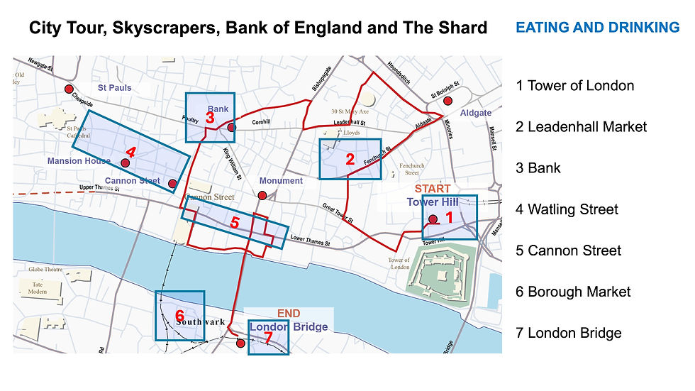
Start: Tower Hill Station
Finish: London Bridge Station
Distance: 4.0 km
Estimated Time: 20-35 minutes
Difficulty: Moderate
Best Time: Early morning weekends
Overview: From Tower Hill Station, this City of London loop passes Aldgate, the Gherkin, Leadenhall Market, the Bank of England, and the Cheesegrater before crossing London Bridge back to London Bridge Station — the City's ancient skyline and its modern one, face to face
The Experience
Starting at Tower Hill Underground Station, this 4.0 km self-guided running and walking route takes you on a circuit of the City of London — London's ancient financial heart, now home to some of the world's most distinctive modern architecture. Head east through Aldgate — a Roman gate into the city — before looping back through the skyscraper cluster: the Gherkin, the Cheesegrater, the Walkie Talkie, and Leadenhall Market. Pass the Bank of England and the Royal Exchange before crossing London Bridge to finish at London Bridge Station by the Shard. Nowhere else in the world can you run from a Roman gate to a 21st-century glass tower in under 4 kilometres
The Familiarisation Guide
Essential information to help you become familiar with the route before you arrive.
Maps
Use the Google and Strava maps below to stay on track. They show your location relative to the route, helping you explore confidently without getting lost.
Please note: These don't provide turn-by-turn directions—we want you present and alert, using your senses, not glued to your screen.

Both maps will open in a new tab.
Watch the Route at Running Speed (Treadmill Version) 18:35
See the route from a runner's perspective as if you were running at 12 km/h. Watch this before you go to familiarise yourself visually with what's ahead.
What to Know Before You Go
Best Time to Stride:
The route can get crowded, so it's best to do this in the early morning—especially at weekends when it's quiet, the light is at its best, and you have the whole day ahead of you.
Why Mornings are best:
In the early morning, the City of London feels almost medieval again—empty streets, dramatic architecture, and that special silence before the financial engines roar to life.
Safety Note:
The route is mainly on City of London roads. Take care with traffic, pedestrians, and crowded areas, especially on weekdays.
Tower Wharf (if doing extension):
Opening times normally 07:00–19:00. Check exceptions at hrp.org.uk/tower-of-london/visit/opening-and-closing-times
Panoramic Views Available:
The Monument – Climb for city views
The View from The Shard – Spectacular panoramas
The Garden at 120 Fenchurch Street – High-level views
Sky Garden at 20 Fenchurch Street (the "Walkie-Talkie" building) – Free but booking required
Top Tip:
Have this guide and your chosen map (Google or Strava) available on your mobile for quick reference.
The Route Connoisseur Guide
Don't just run the route - get to know it!
Eating and drinking areas
Things to Do and Visit,
Sightseeing Gallery
Where to Eat & Drink
Key Dining Areas:
Borough Market – Incredible variety and quality
Watling Street – Excellent selection of restaurants and pubs
Leadenhall Market – Historic setting with dining options
Cannon Street – Good variety
Around Tower of London – Quality hotels and traditional pubs
Things to Do
Ticketed Attractions:
The View from The Shard – London's highest viewing platform
The Monument – Climb 311 steps for panoramic views
Sky Garden and The Garden at 120 Fenchurch Street – High-level city panoramas
Tower of London – Medieval fortress
Bank of England Museum – Financial history
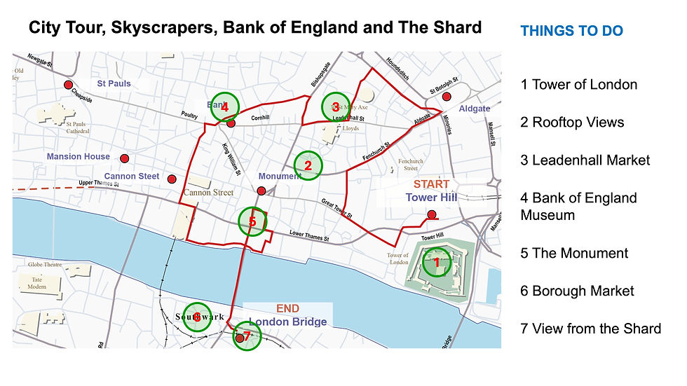
Free to Explore:
Leadenhall Market – Beautiful Victorian covered market
Borough Market – Browse and sample (food purchases optional)
Lloyd's Building – Stunning modern architecture (exterior)
Bank Junction – Historic financial heart
Royal Exchange – Grand architecture
The Sightseeing Gallery Guide
Once you know the route, dive deeper into the stories and sights that make this stride special.
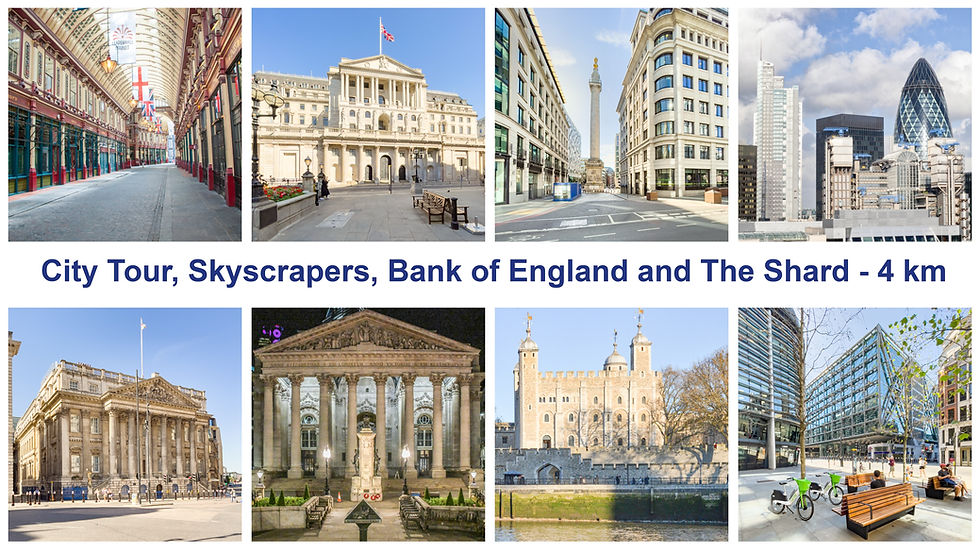
Key Sights Along the Way
Tower of London
Fenchurch Street
Aldgate
Leadenhall Market
The Gherkin and Lloyd's Building
The Bank of England
Royal Exchange
Mansion House
The Monument
Borough Market
The Shard
London Bridge
Explore the gallery below for photos, history, and the stories behind each location.


360° Virtual Tour
Step into the route before you stride it—or relive your experience afterwards. Click the map below to explore interactive 360° views at key locations along the way.

The virtual tour opens in a new tab with a map showing all 360° locations. Click any location icon to be transported to that spot.
Follow-on Routes
Stride It Backwards:
Complete the route in reverse to experience London's ancient heart from a different perspective.
Previous Route: London Bridge, Tower Bridge and the Tower of London – 2.9 km
Alternative Previous Route: Limehouse, Shadwell, Wapping, St Katharine Docks – 4.7 km
Complete The City of London Collection Challenge- 14.4km:
This route is number 8 and the third one of the City of London collection
